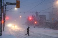
People walk through downtown Toronto, as Environment Canada warns of peak snowfall rates of five to eight centimetres per hour as a winter storm moves through the region, Sunday, Jan. 25, 2026. THE CANADIAN PRESS/Cole Burston
People walk through downtown Toronto, as Environment Canada warns of peak snowfall rates of five to eight centimetres per hour as a winter storm moves through the region, Sunday, Jan. 25, 2026. THE CANADIAN PRESS/Cole Burston
TORONTO - Environment Canada says prolonged periods of extreme cold are expected this weekend for much of southern Ontario, including the Greater Toronto Area where it could feel like -30 with the wind chill.
The bone-chilling cold will hit Toronto Friday night into Saturday morning, and is predicted to return Saturday night into Sunday morning before letting up slightly on Monday.
The weather agency says Toronto could also see powerful wind gusts of up to 80 kilometres per hour and local blowing snow Friday evening.
A blizzard warning is also in place for areas near the shore of Lake Huron, northwest of London, Ont., that could bring up to 20 centimetres of snow starting Friday afternoon.
Environment Canada says the extreme cold will also hit vast areas of central and northeastern Ontario.
The weather agency says frigid temperatures pose dangers such as frostbite to everyone, but warns the risks are far greater for young children, older adults and those without proper shelter.
This report by �����ջ��� was first published Feb. 6, 2026.
Note to readers:This is a corrected story. A previous version stated Lake Huron was northeast of London, Ont.